Add or import an alignment
Who can do this
Owners, administrators, and colleagues who can add work to the project (branch managers and members, project leads and contributors). People who can only read a project cannot add or change alignments. See Compare all features under Billing for the plans that include corridor review.
An alignment is the centre line of a road, canal, railway or pipeline, kept with a project so you can review it by chainage.
Alignments work in projects recorded in EPSG:32643 (UTM zone 43N), eastings and northings in metres. You add them in the flat 2D map, on a larger screen.
- Open Projects, choose the project, and select Open map on the map at the top of its page. The map opens.
- Select Analyse in the rail on the left of the map, then New alignment under Corridor review. The alignment form opens.
- Type a Name, the Start chainage (m) (the chainage of the first vertex, often 0) and the Station interval (m).
- Under Stations at the ends, choose Include the start and the end or Interval stations only.
-
Give the vertices in order of travel, in one of three ways:
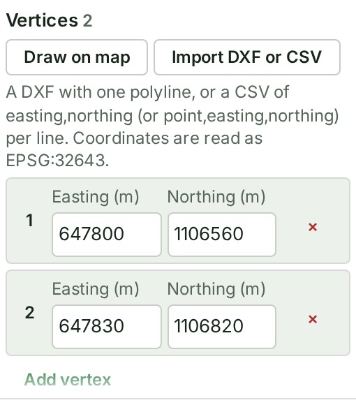
- Type each Easting (m) and Northing (m), using Add vertex for the next row.
- Select Import DXF or CSV and choose the file.
- Draw them on the map:
- Select Draw on map.
- Click the map at each vertex in order of travel.
- Select Done in the Inspector.
-
Check the line under the vertices, for example Preview in this browser: 261.725 m, 12 stations.
- Select Save. The panel says Saved as version 1.
What happens next
The alignment is chosen in the list, with its stations on the map. Every later change is saved as a new version; the earlier one is kept.
Files you can import
| Format | What it holds | Refused |
|---|---|---|
| DXF | One polyline (LWPOLYLINE or POLYLINE) | An arc, circle, ellipse, spline, helix or a curved polyline segment |
| CSV | One point a line, as easting,northing or point,easting,northing; a first line naming the columns (such as Easting,Northing) is read as a header; semicolons, tabs and spaces also separate the values | A line that is not an easting and a northing |
Coordinates are read as EPSG:32643 eastings and northings. An alignment has from 2 to 2000 vertices.
If something goes wrong
- The file holds a curve ({entity}). Alignments take straight sections only: convert the curve to short straight sections in your CAD software and import it again. Do that, then import the file again.
- The file holds … polylines. Import one alignment at a time: keep only its polyline in the file. Keep only the one polyline in the file.
- Line 4 of the file is not an easting and a northing. Correct that line of the CSV and import it again.
- The alignment turns back on itself at vertex … or This alignment crosses or touches itself … Split it into two alignments that do not cross.
- At this interval the alignment would have … stations, and at most 10000 are kept. Choose a longer Station interval (m).
- Somebody else changed this alignment while you were editing. Select Reload, then make your change again.
- Your organisation’s plan does not include creating or changing alignments. The alignments already in this project can still be read. An Owner or Billing manager can change the plan. Ask one of them to open Billing and choose Compare all features.
The product words on this page are explained in the glossary.